What is the Volga known for? But where does the Volga flow into? Territorial division of the river
Provided her with a significant role in the development of trade and the formation of large cities of the Slavic tribes. The Volga is the largest river in Europe. Even today it remains an important source of fresh water and electricity, a transport highway, and also attracts a large number of vacationers and tourists to its shores. Where is it located and what are its features? This will be discussed below.
Volga: geographical location
The river adorns the European part of our country. A small branch of the main channel flows through the territory of Kazakhstan. The source of the Volga is located on the Valdai Hills (229 meters above sea level). As is commonly believed, the mighty river begins near the village of Volgoverkhovye, Tver Region. The Volga basin occupies about a third of the European territory of Russia. It extends from the Valdai and Central Russian uplands up to the Urals.
The Volga is considered the largest river in the world that does not flow into the ocean. It carries its waters to the Caspian Sea, to the basin of which it belongs. The length of the river is 3530 km, the total fall is 256 m. The Volga basin covers an area of over a million square kilometers.
It is customary to divide the Great River into three parts: the upper (from the source to the mouth of the Oka), the middle (from the mouth of the Oka to the confluence of the Kama), and the lower (from the mouth of the Kama to the Caspian Sea).
Source
The river originates from a spring flowing from a swamp near the village of Volgoverkhovye. A temple was built nearby. The very source of the Volga is located under the floor of a small wooden chapel on stilts. It is equipped with a special window through which it is allowed to scoop up and drink water.
Approximately three kilometers from the source, the Volga flows alternately into two lakes: first into the Small Verkhity, and then into the Bolshaya Verkhity. Further, its path runs through the Upper Volga reservoir. The first large lake related to it is Sterzh. The Volga invades its waters with great force, swiftly, without mixing, overcomes them. It is said that on sunny days you can see the river flowing through the lake.
Upper Volga
Before the creation of reservoirs, the length of the river was longer and amounted to 3690 km. The first dam along the river is located after the Upper Volga lakes (Sterzh, Vselug, Peno, Volgo). It was built in 1843. There are several reservoirs on the Upper Volga today: Ivankovskoye (also referred to as a hydroelectric power plant near the city of Dubna), Uglichskoye, Rybinskoye, Gorkovskoye (located near Gorodets, above Nizhny Novgorod).
The first major settlement from the source of the river is Rzhev. On the Upper Volga there are such ancient cities as Kostroma, Tver, Uglich and Yaroslavl. It flows through a picturesque area, now spreading widely, then narrowing between steep banks.
The main tributaries of the river in this segment are: Selizharovka, Darkness, Kotorosl, Tvertsa, Mologa, Sheksna, Unzha.
Middle Volga
After the confluence of the Oka, the river flows at the right edge of the Volga Upland. Here it becomes noticeably more full-flowing. The right bank of the Volga is high, while the left bank is low.
Near the city of Cheboksary there is a hydroelectric power station with a dam, above which there is a reservoir.
The main tributaries of the river in this segment are: Oka, Sura, Vetluga, Sviyaga.
Lower Volga

The river acquires its full power and strength after the confluence of the Kama. On this segment, it flows along the Volga Upland. Going around the Zhiguli Mountains, the Volga forms the Samara bow. The Kuibyshev reservoir is located slightly higher than it (the Saratov hydroelectric station is adjacent to it. Near Balakovo, on the river, there is the Saratov hydroelectric power station. In the Volgograd region, the river approaches the Don. A little higher than the city, the left arm, Akhtuba, separates from it. Its length is 537 km. Between the river and its arm is located the so-called Volga-Akhtuba floodplain, consisting of a large number of channels.
Not far from Volgograd, on the section of the river between the city and the beginning of Akhtuba, there is the Volzhskaya hydroelectric power station and
The tributaries in this section of the river are quite small. These are Sok, Samara, Big Irgiz, Eruslan.
Mouth of the Volga
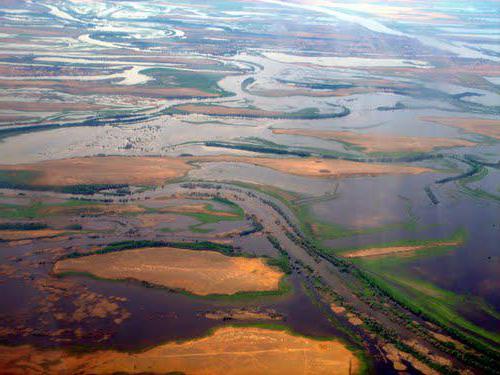
In the area of approach to the Don, the river turns and flows further to the southeast until it flows into the Caspian Sea. In the place where the Akhtuba separates from the main channel, the Volga delta begins. It covers an area of approximately 19 thousand square kilometers. Delta consists of 500 arms. The largest of them are Akhtuba, Bakhtemir, Kamyzyak, Staraya Volga, Bolda, Buzan. The second branch of these is constantly maintained navigable and forms the Volga-Caspian Canal. Kigach, which is also one of the branches of the great river, crosses the territory of Kazakhstan.
Considered the largest in Europe. Throughout history, it has changed its position and occupied area. The delta of the modern type was formed around the 3rd century AD, when the old channel could not cope with the increased volume of water. Over the past 130 years, the level of the Caspian Sea has been decreasing. As a result, during this period, the area of the delta increased by about 9 times.
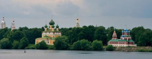
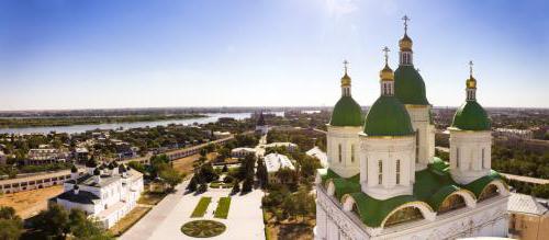
At the mouth of the Volga is the last city on this river - Astrakhan. It is located on eleven islands in the upper part of the delta.
Nutrition and mode
The Volga River, whose geographical position was discussed above, before the construction of reservoirs was characterized by significant level fluctuations (below the mouth of the Kama, they reached 17 m). Today, such serious drops and spills are not observed.
Most of the river is fed by snow waters (up to 60%). A significant role in this process is also played by rain (10%) and ground (30%) “inflows”. Throughout the year, the Volga goes through several successive transformations. Spring (April to June) is high water. In summer and winter, the level in the river decreases markedly. In autumn (usually in October) there are rain floods.

During the hottest months, the water temperature in the river reaches 25º. The Volga freezes in the upper and middle sections, as a rule, in November, in the lower section - not earlier than December. The river is freed from ice first of all near Astrakhan (in March). The Upper Volga, as well as the area below Kamyshin, opens up in the first half of April. The rest of the river comes out of its winter slumber in the middle of this month.
Natural resources
The Volga on the map occupies a vast territory. It flows through the forest, forest-steppe zone and steppe. The river has been famous for its fish wealth since ancient times. Bream, roach, sterlet, carp, catfish, pike live here. Unfortunately, the construction of reservoirs and water pollution do not contribute to the conservation of all this diversity. A nature reserve has been created in the Volga Delta. Since 1919, unique plants and animals have been under state protection on its territory. Among them are lotus, sturgeons, pelicans, flamingos.
The Volga (geographical position, nutrition, unique flora and fauna) is well studied today. Along with the understanding of the changes that have taken place with the river throughout the entire time of its existence, comes the awareness of the problems associated with them. Today, the great Russian river is in dire need of protecting its wealth. Fortunately, more and more people are becoming aware of the dangers of environmental problems. One can therefore hope that the unique nature and beauty of the Volga banks will be preserved for many more centuries.
The Volga River is one of the most amazing water arteries of Russia created by nature. Its fullness, at times, is simply impressive - in some places, the opposite coast cannot be seen without binoculars. And the length from source to mouth is more than 3500 kilometers. It is the longest river in Europe. Traveling along the Volga is remembered for a long time. This impressed the inhabitants of ancient times and amazes modern inhabitants.
The beginning of the path of the Volga is the Valdai Upland, namely: the Ostashkovsky district of the Tver administrative district. Not far from the small village of Volgoverkhovye there are many springs and springs, one of which forms the source of the mighty water artery of the country. Near the spring there is a chapel, a bridge is equipped, passing through which, everyone can observe the birth of the Volga River. All the springs near the village form a small reservoir, from which flows a barely noticeable stream, having a width of no more than a meter. It should be noted that the Volga River originates at an altitude of 228 meters above sea level and flows in a northeasterly direction.
The stream, as the beginning of the Volga River, has a length of more than three kilometers. It passes through the lakes Small and Big Verkhity, after which it becomes like a small river. Further, the Volga River enters Lake Sterzh, which has a total water area of 18 sq. km. Sterzh, like other lakes, is an integral part of the first reservoir in the cascade - the Upper Volga.
Geographers tacitly divided the river basin into several massive parts: the Upper, Middle and Lower Volga. After 200 kilometers from the beginning of a small stream, already on the sound Volga River, there is an ancient Russian city of Rzhev. The next big city with a population of almost half a million inhabitants is Tver, where the Ivankovskoye reservoir with a total length of 120 km has been artificially created. Next come the Uglich and Rybinsk reservoirs. The city of Rybinsk can be considered the extreme northern point of the reservoir, after which the channel of the Volga River changes direction to the southeast.
A hundred years ago, overcoming many obstacles in the form of hills and lowlands, the river did not differ from many other waters in its wide channel. With the development of technological progress, these virgin places were swallowed up by the Gorky reservoir, which stretched for 430 kilometers. Such well-known administrative centers of Russia as Rybinsk, Yaroslavl and Kostroma are located along its banks. The man-made sea itself is formed by the Nizhny Novgorod hydroelectric power station, located a little higher than Nizhny Novgorod.
In Nizhny Novgorod, the Volga meets its largest right tributary, the Oka. Its length to the confluence of the rivers is 1500 km. It is here that the Middle Volga originates.
Saturated with the waters of the Oka, the Volga becomes a river of a completely different plan. This is already a powerful, full-flowing river with its own character. Here the channel gently turns to the east. Flowing along the Volga Upland, the Cheboksary hydroelectric power station blocks its path, forming a man-made lake of the same name with a length of 340 kilometers and a width of about 16 km. Further, the current shifts to the southeast, and near Kazan it turns south. By the way, Kazan, the capital of the Republic of Tatarstan, is one of the oldest settlements in the Russian Federation. And the Kazan Kremlin is included in the list of UNESCO World Heritage Sites.
After the confluence with the Kama, the Volga, like a river, turns into the most full-flowing, deep and powerful. Although, according to all the laws of hydrology, it would be more correct to consider the Kama as the main river, and the Volga as its tributary, since the Kama is much older and more full-flowing, and its drainage does not decrease at any time of the year. However, in view of the historically established traditions, the Russian geographers decided to make an exception and consider the Volga as the main river, and the Kama as a tributary.
After uniting with the Kama, the waters of the river constantly rush to the south. Here is the world's third largest artificial reservoir - Kuibyshev. In some places, the width of the reservoir reaches forty kilometers, and the length is 500 km. Leaving Ulyanovsk behind, near Togliatti and Samara, the Volga forms a large bend, bypassing the Togliatti mountains. Further, the Volga flows past Samara and Saratov with the same names of reservoirs.
In the Volgograd region, a river delta is formed, the length of which is 160 kilometers. This is the most voluminous river mouth in the European part of Russia. It has almost half a thousand different branches, canals and channels flowing into the Caspian Sea.
On the way, such a river as the Volga passes through the lands of four republics and 11 administrative districts of the Russian Federation and partly through the Atyaur region of Kazakhstan. 3500 kilometers of unique landscapes, rare flora and fauna, historical and cultural sites. No wonder they say that the Volga is the most beautiful river in Russia.
Hydrological regime of the Volga river
The river is fed in three ways. The main flow of water into the Volga (up to 60%) occurs as a result of snowmelt. Groundwater and rainwater recharge account for 60 and 30 percent of the total fluid intake, respectively. Due to this feeding habit, the river is characterized by low water content in the summer months and spring floods. There are cases when the Volga River in the Novgorod region became so shallow that navigation practically froze. Previously, annual water level fluctuations reached 14-16 meters in the middle reaches of the river, but with the construction of a cascade of reservoirs, the fluctuations have decreased. However, in inclement and windy weather, waves up to 2 meters high occur in the waters of the reservoirs.
Before the construction of artificial reservoirs, up to 25 million tons of sedimentary soils were carried out of the Volga per year. At the present time, this figure has halved. Such human activity has led to a change in the ecosystem of the river and the thermal regime of the reservoir. Now the duration of ice phenomena in the lower reaches of the river has decreased, and at the headwaters it has become longer.

Wildlife on the Volga River
Due to various natural features, the river is replete with numerous representatives of flora and fauna, including species listed in the Red Book. Although recently the ecological situation leaves much to be desired, on the Volga River you can meet a huge number of waterfowl: various types of ducks, dives, swans, and even flamingos in the delta. In general, the Volga delta, like rivers, is the largest nesting place for birds, more than 260 species are represented. Beavers, otters, raccoons and other fur-bearing animals are not rare here. But the main wealth of the reservoir is the ichthyofauna.
Since ancient times, the Volga has been considered a river rich in fish resources. And in our time, fishing on the Volga is very popular with many lovers of this activity. There are 76 species and 47 subspecies of various fish in the river. Permanent inhabitants are: catfish, crucian carp, carp, perch, sterlet, roach, bream, crucian carp, blue bream and many others. Of the anadromous species, there are: sturgeon, stellate sturgeon, spike, beluga, whose black caviar is known throughout the world, as well as the Volga and ordinary herring. Such an abundance of species composition allows commercial fishing throughout the river from source to mouth. And the size of some species is impressive. The length of the smallest granular fish does not exceed 2.5 cm. The largest fish that is found in the Volga River Delta, the beluga, can grow up to 4 meters in length and weigh about 1 ton.
Due to the considerable length of the riverbed, the soil cover of the Volga basin is very diverse. But for the most part, these are fertile chernozems and soddy-podzolic soils, as evidenced by abundant vegetation.
Navigation on the Volga River
The Volga River is not only a large body of water in the European part of Russia, but also an important transport artery of the country. And although recently little attention has been paid to water transport, a fairly large amount of cargo, both local and international, is transported along the Volga. This was largely facilitated by the creation of many artificial channels that provide a connection between the river and the seas:
Black and Azov Sea - Volga-Don Canal;
Baltic Sea - Vyshnevolotsk and Tikhvin canal systems;
White Sea - Severodvinsk and Belomorkanal.
Thus, the flow of cargo ships along the Volga does not dry out. The only obstacle can be only the period of freezing.

Volga river in history
It is believed that one of the first mentions of the Volga was made in the 5th century BC in the treatises of the ancient Greek philosopher and historian Herodotus. In describing the military campaign of the Persians led by King Darius against the Scythian tribes, the historian points out that the army of Darius, pursuing the tribes beyond the Tanais or Don river in the modern presentation, stopped on the banks of the Oar River. It is this name that scientists identify with the Volga River.
There was not much information about the river in ancient times. So Diodorus Siculus gave the name to the river - Arax, and Ptolemy argued that the Volga had two mouths that flow into different seas: the Caspian and the Black. Roman philosophers gave it a name - Ra, which means "generous", the Mongol-Tatar tribes called it Rau, Idel, Iuil, and in the Arab primary sources the Volga is called Atelya (great). Many philologists claim that the modern name arose from the Baltic word - "valka", which means "flowing stream". Another group of scientists is inclined to believe that the root of the word Volga comes from the Old Slavonic word "moisture". The well-known Russian chronicle "The Tale of Bygone Years" also affects the Volga. It clearly traces the path of the river - where it originates and where it flows.
The heyday of trade in Russia coincided with the time when the Volga River was under the rule of Ivan the Terrible. It was then that a huge number of caravans with goods from the east walked along the river surface. Fabrics, silver, metals, jewelry were delivered to the capital by Arab merchants. Expensive furs, honey, wax and much more were brought back. Trade along the banks of the river is actively developing, cities and villages are growing.
The Volga acquired special strategic importance in the 19th century. At that time, a large river fleet appeared on the river. Mass transportations of grain and salt, ore and fish, and other raw materials are carried out. Over time, in addition to sailing and rowing ships, steamboats appeared. But the Volga river is not navigable in all areas. In some places, the passage of ships was difficult. This is how a manual method of transporting boats, barges, etc. arose. People harnessed themselves to a special harness and, using ropes, pulled the ship along the river. It was very hard and thankless work. During the period of active cargo flow, more than 300 thousand people worked in the water area. Such people were called barge haulers. Russian artist Ilya Ivanovich Repin was able to accurately convey the entire terrible and tragic fate of hired workers in his painting Barge Haulers on the Volga.
The Volga river and wars did not bypass. During the years of the Civil War, and then the Great Patriotic War, the Volga remained a strategic object that controlled access to grain, oil and other vital resources. The turning point in World War II is the Battle of Stalingrad, which took place on the banks of the long-suffering river.
The post-war period is characterized by strong economic growth of the country. Numerous hydroelectric power plants are being built at a rapid pace with the formation of reservoirs. The value of the Volga as a river of strategic and economic importance has increased several times. New jobs have been created, cities are being actively rebuilt, and the flow of freight water transport is growing inexorably.

Legends and folklore about the Volga River
People have long settled along the banks of rivers, and the Volga was no exception. Water and the availability of food make riverbeds attractive for habitation. Our ancestors firmly believed that each, even a small river, has a spirit or guardian. And such large and full-flowing rivers as the Volga could have several of them. According to legends and traditions, the Upper Volga has a guardian who appeared before eyewitnesses in the form of a little girl. The little girl never cries and has saved drowning children many times.
The legends of the Middle Volga claim that the spirit of the river is a young beautiful girl. She is often referred to as a nurse or intercessor. It used to be believed that the color of the water on the Volga largely depends on the mood of the keeper of the river. The darker the water, the worse the mood of the keeper and nothing good can be expected.
In the lower reaches of the river, an old man with a large gray beard and one bast shoes watches over the order. Why in one? The answer to this question has not reached our days. But they say that the old man appears only in front of those who are pure in soul and indicate places full of fish, and people with a "black heart" are pulled under water, where they remain forever.
The mention of mermaids on the Volga River is also not uncommon. But each region has its own characteristics. In one, mermaids are completely harmless and cute creatures, and in the other, they are vicious and very dangerous.
Not only legends about river inhabitants have survived to this day. The Volga River is sung in many folk songs. Many works have been written about the river, feature films and documentaries have been shot. What is the well-known old film "Volga-Volga" worth to everyone. Yes, and modern authors do not disdain to pay tribute to the river.
Facts and figures about the Volga River
It is impossible to describe the Volga only in words as a river, which is one of the largest in the European part of our planet. The language of dry numbers will say more.
The length is 3500 kilometers. However, it should be borne in mind that before the construction of the cascade of man-made lakes, the length of the Volga was 110 kilometers longer.
The mouth of the river consists of almost 500 independent canals, branches, rivers, branches and channels.
On average, the speed of the current in the channel of the Volga River is 3-6 km/h.
In order for water to reach the sea from the source, on average, 37 days must pass.
The river system of the Volga basin consists of 150 thousand different rivers, streams, tributaries and other watercourses.
The mouth of the river is located 28 meters below sea level.

Excursion along the Volga - a lot of impressions
Naturally, talking about all the delights of a mighty water stream or at least once seeing the beauty of the Volga River with your own eyes are incompatible things.
Traveling along the river is not difficult at all. With the current developed infrastructure and small remoteness of settlements from each other, it will not be difficult to organize a tour of the expanses of water.
Where to stay? A large number of recreation centers located almost along the entire coast of the river, hotels in district and regional centers, are happy to accept both groups of tourists and single travelers. The locals will also help out - in almost every village you can stop for a stay, hear local legends and taste rural delicacies.
What to watch? There are many museums in the cities, churches in the villages, and the picturesque nature of the Volga and the surroundings of the river will not let you get bored throughout the trip. And for avid fishermen, fishing on the Volga will be a real break from city worries and fuss.
The Volga is a truly amazing river. See for yourself when you come here to travel or just relax.
Volga river the largest and deepest river in Europe. The ancient name of Ra (lat. rha) the less old name of Vloga is Itil, the river received in the Middle Ages. It is the largest river that does not flow into the sea. 2/3 of Russia's population lives in the Volga basin. Its source is located on the Valdai Upland at an altitude of 256 m above sea level. And at the mouth, on the northern coast of the Caspian Sea, in its delta, there are the largest lotus fields in the world, covering hundreds of hectares.
Here is what Alexander Dumas wrote about the Volga: “Each country has its own national river. Russia has the Volga - the largest river in Europe, the queen of our rivers - and I hastened to bow to Her Majesty the Volga River!
River length: 3,530 kilometers.
Watershed area: 1,360 thousand sq. km.
highest point: Mount Bezymyannaya, 381.2 m (Zhiguli Mountains).
Channel width: up to 2500 m.
Slope and fall: 256 m and 0.07 m/km (or ppm), respectively.
Average current speed: less than 1 m/s.
River depth: the average depth is 8 - 11 meters, in some areas 15 - 18 meters.
delta area: 19,000 sq. km.
Average annual flow:>38 km3
Where does it run: The Volga originates in one of the most elevated parts of the Valdai plateau in the Tver region. It flows from a small spring in the middle of swampy lakes, not far from the village of Volgoverkhovye. The source coordinates are 57°15' north latitude and 2°10' east longitude. The height of the source above sea level is 228 meters. The Volga flows through the entire central lowland of European Russia. The river bed is meandering, but the general direction of flow is east. At Kazan, approaching almost the very foothills of the Urals, the river turns sharply to the south. The Volga becomes a truly mighty river only after the Kama flows into it. At Samara, the Volga breaks through a whole chain of hills and forms the so-called Samara bow. Not far from Volgograd, the Volga approaches another mighty river - the Don. Here the river again makes a turn and flows in a southeasterly direction until it flows into the Caspian Sea. At the mouth of the Volga forms a vast delta and is divided into many branches.
River mode, food: Most of the water comes from groundwater, and to a lesser extent, food comes from precipitation.
Freezing: The Volga is covered with ice in late October - early November and remains under it until the end of April - mid-March.
Tributaries: About 200 tributaries flow into the Volga. The largest of which are Kama and Oka, as well as smaller streams such as: Unzha, Kerzhenets, Sura, Tvertsa, Medveditsa and others.
It has not yet been decided whether it is possible to consider that the Kama flows into the Volga. Since, according to the rules of hydrography, it turns out that everything is exactly the opposite, and it is the Volga that should flow into the Kama. Since the Kama is older by origin, it has a larger basin and tributaries too.
The direction of flow in most of the river is from north to south. Between the tributaries of the Oka and Kama, the Volga has a predominantly latitudinal course.
For centuries, the Volga has served people as a source of clean water, fish, energy, and a transport artery. But today it is in danger, human activity pollutes it and threatens with a catastrophe.
The favorable geographical position of the river and human activities in the construction of canals have turned the Volga into the largest transport artery. In addition to the Caspian Sea, it is connected to 4 more seas: the Baltic, White, Black and Azov. Its waters irrigate fields, and its hydroelectric power plants provide electricity to entire cities and major enterprises. However, intensive economic use has led to the pollution of the Volga with industrial and agricultural waste. Huge areas were flooded during the construction of dams.
Ecologists say that the ecological situation is critical and the river's ability to self-purify has been exhausted. Blue-green algae capture more and more territories every year, fish mutations are observed. The Volga is called one of the dirtiest rivers in the world. Ecologists may like to dramatize, but if it's too late, it will be much worse. In any case, there are problems. Therefore, the protection of the river is very important now.
Home — Annecy Lake, Haute Savoie, France
The Volga - the largest river in Europe - originates in the Ostashkovsky district of the Kalinin region in a swampy forest, not far from the village of Volgo-Verkhovye. Here, among the mosses and swamps of the Valdai Upland (at an altitude of 221 meters above sea level), a small stream flows out. This stream is the beginning of the great Russian river.
The Volga stream slowly seeps through the swamp. Only after a few tens of kilometers does the current become noticeable. But what a small and weak Volga is here! It is possible to step over. Every oncoming stone, stump, every flowing stream force the Volga to turn to the side.
For the first ten kilometers, the Volga flows through a number of lakes. In them, she replenishes her supply of water and gradually grows, swells. Since the sources of the Volga lie low, it flows along a very gentle channel. Therefore, its flow rate is low.
After a long journey through the swampy slums, where the forest is replaced by a swamp, the swamp is replaced by a forest, the Volga flows through the large lake Volgo. Below it, a dam was made on the Volga. Here, from one bank of the Volga to the other, it is already 35 meters. This dam (beishlot), the first along the stream, consists of a series of abutments that hold shields blocking the river. A road bridge is thrown over the abutments.
The dam raises the water level in the Volga above the Beishlot; when the shields are closed and the reservoir is full (in spring), the Volga's currents are not visible - it merges into one with the lakes over a forty-kilometer space. When the Volga begins to shallow by summer, the shields are raised. The excess of spring water gradually descends during the summer, preventing the river from becoming shallow downstream. The influence of the Beishlot affects downstream to the confluence of the Mologa River into the Volga.
Thanks to the beishlot, the non-navigable Volga at the headwaters becomes a raftable river. A lot of wood was rafted along it. The Volga Beishlot was built in 1834, reconstructed in recent years and is a successful attempt to regulate the upper reaches of the river.
From Beyshlot to Tver, the Volga is in places full of rapids. The rapids consist of stone ridges and individual stones - boulders brought here by the glacier.
The Volga begins to take its tributaries beyond the beishlot. The first is Selizharovka, flowing from the large lake Seliger, then Vazuza, Tvertsa. Having accepted them, the Volga becomes full-flowing.
In the upper reaches, before the confluence of the Volga with the Oka, there is still no sharp contrast between the right and left banks of the Volga. Only after the confluence of the Oka, the right bank will become high and steep, and the left bank will become low.
Previously, the right and left banks turned out to be steep. The steep high bank has a concave shape, the low one is convex.
The Volga Stream and the Volga River up to the Beishlot and somewhat below it flows somehow uncertainly. It's like she's groping her way. She has to lay the road among clay deposits and limestones. The Volga still does not have enough strength to wash itself here and develop the valley.
The Volga begins to erode its valley only beyond Rzhev. Here the path of the river goes through clay-sand strata. They are easier to wash out than limestone, and the Volga is getting bigger and stronger.
The section of the Volga from Tver to Ivankovo is flooded with a huge reservoir or, as it is called, the Moscow “sea”. This "sea" is formed by a large dam built on the Volga near the village of Ivankovo and which is the head structure of the Canal. Moscow.
The Moscow "sea" in the life of the Volga is not quite a common occurrence. It is like a renewed section of a great river. Here the Volga is wide and deep.
Downstream from the Ivankovskaya dam, the Volga dramatically changes its appearance. Here it is narrow, flows within the channel banks, until it overflows with the Uglich reservoir near the city of Uglich. It reaches its maximum width in the immediate vicinity of the Uglich hydroelectric complex. The reservoir is the second large artificial reservoir that ensures uninterrupted navigation of ships on the Upper Volga.
Downstream begins the Rybinsk reservoir. In the upper part, it is not yet large and fits within the channel banks. But in the middle part of the Volga overflows its banks and spreads widely in its valley. The closer to Rybinsk, the wider the reservoir. In some places, the flood of the Volga is so great that the coast is not visible from the ship. The Rybinsk reservoir, built in 1940 (it was filled with water from 1941 to 1947), was at that time the world's largest artificial reservoir. It provides water for the powerful turbines of the hydroelectric station, and helps navigation. Further along the Volga, a whole cascade of reservoirs and hydroelectric power plants begins.
Most of the tributaries of the Volga flow into it in the upper and middle reaches. The largest of the tributaries - the Kama and the Oka - are themselves large flat rivers. The main right tributary of the Volga Oka flows into Nizhny Novgorod. Here, in its width, it almost does not differ from the Volga. The length of the Oka from its source to its confluence with the Volga is 1,465 kilometers. The sources of the Oka are located within the Oryol region near the villages of Ochka and Aleksandrovka. The upper course of the river passes on the border of forests and forest-steppe. The right bank of the Oka and the plain adjacent to it are covered with forest-steppe, and the left side is covered with sandy soils and coniferous forests. The left bank of the Oka is low and gentle. It is rich in numerous backwaters, lakes and beautiful water meadows.

On the meadows of the Oka floodplain, you can find such vegetation as tulips, iris, white anemones, red geraniums, bison and other representatives of the southern flora. In the clear waters of the Oka, there are many varieties of valuable fish - sterlet, sturgeon, ide, pike perch, bream, etc.
The Prioksko-Terrasny Nature Reserve, founded in 1945, is located in the Oka Valley near the town of Serpukhov. Beavers live here, a rare Siberian Crane, listed in the Red Book. Bison are bred in the nursery.
Not far from the mouth of the Oka, on the left side, the Klyazma River, one of its largest tributaries, flows into the Oka.
Having accepted the Oka, the Volga becomes twice as full-flowing and wider. Before its next largest tributary, the Kama, the Volga receives a number of small tributaries: on the left side, the Kerzhenets, Vetluga, Bolshaya Kokshaga, and on the right, the Sura and Sviyaga. Below Kazan, the Volga receives its main tributary, the Kama.
The length of the Kama is 1800 kilometers. It has a basin equal to one third of the entire Volga basin, and receives such large tributaries as the Vishera, Chusovaya, Belaya, Vyatka, etc.
Kama originates within the Kirov region near the village of Karpushina and becomes navigable already 40 kilometers from the source.

The northeastern tributaries of the Kama - Chusovaya, Ufa, Belaya and others - originate in the mountains of the Middle and Southern Urals. One of the largest commercial and industrial centers of the Urals - the city of Perm - is located on the banks of the Kama.
The transport significance of the Kama, as a natural route connecting the industrial Urals with the Volga, is of great importance for the country.
Unlike other tributaries of the Volga, the Kama is full of water and swift in its course. The average slope of the Kama is twice the average slope of the Volga.
The middle and lower reaches of the river are accessible to large vessels. At the confluence of the Kama into the Volga (Kama mouth), a sharp difference in the color of the water is striking. Kama carries dark bluish water, and Volga - yellowish-gray.
Kama brings much more water than Oka. Its flow is equal to that of the Volga near Kazan. The Volga, after confluence with the Kama, becomes a mighty water artery.
Along the right bank of the Volga, from Nizhny Novgorod to Volgograd, the Volga Upland stretches, in which the Zhiguli Mountains deserve special attention - the highest place on the right bank of the Volga (370 meters above sea level).

In ancient times, when the Alps, the Caucasus Mountains and other mountain ranges arose on the earth under the influence of powerful mountain-building processes, a wave of grandiose displacements of the earth's crust swept through Europe and Asia. Such movements took place on the site of the current Zhiguli. Curving into a fold, the hard calcareous layers in the area of the Samara bow broke, forming a crack.
Layers lying to the north of the fissure have sunk into the depths of the earth. There was a so-called reset, the raised wing of which is the modern Zhiguli Mountains. The lowered wing of the fault is a flat surface, on which the Volga now flows.
To the south of the mouth of the Kama, the Volga enters the forest-steppe zone (along the right bank to Saratov and along the left bank to Samara). There is little rainfall here, and summer lasts up to four months. To the south of the forest-steppe lies a zone of open steppe, and then the Volga makes its way to the Caspian Sea in a semi-desert region.
In the delta section of the Volga, in the region of the Volga-Akhtuba floodplain, there are favorable conditions for the development of cotton growing and horticulture.
A section of the Volga-Akhtuba floodplain is flooded with Volga water, and the best varieties of watermelons, melons, grapes, tomatoes, peaches, quince, apricots and other southern plants grow well here.
Everything here is striking in its freshness and brightness of colors: the blue sky without a single cloud, the blue water, the impassable green jungle of reeds. It is difficult to determine what dominates in the delta - water or green vegetation.
The countless islands of the Volga delta are covered with dense thickets of reeds, in which masses of southern birds huddle. Cormorants, black with a greenish metallic sheen, sit on the shore stones from morning to evening and tirelessly fish. Pink pelicans with huge beaks and bright red eyes glide smoothly on the mirror surface of the water. Wild ducks, geese, gulls and hundreds of species of other birds find their shelter in impenetrable reed jungles.
The Volga delta is the realm of fish, reeds and birds.
A scientific reserve has been created in the Volga delta. The abundance of sun and moisture, the extraordinary fertility of the soil create exceptional conditions here for the growth of the rarest varieties of southern plants. In the reserve you can see, for example, such a unique plant world as the lotus - the sacred flower of the ancient Egyptians. This is a very interesting marsh plant. It has large shield-shaped, waxy leaves and very large fragrant pink or pale cream flowers. They bloom only three days a year. Lotus in Europe blooms only in the Volga Delta.
In former times, in winters, when a lot of snow fell in the Volga basin, and the spring was warm and friendly, a huge amount of water rolled into the Volga bed. Level rises in some high-water years reached 14-17 meters. So, above the low horizon, the water in the river rose to the height of a four-story building! Then the river overflowed its banks, and its hollow waters overflowed for tens of kilometers, flooding coastal cities, villages, meadows, arable lands.
“The Volga and Samara, overflowing into boundless space, were agitated: huge brown shafts rose on the surface of the water and tossed ships like chips ... Houses, roofs, fences, various household utensils were swept over the water in masses ...” - this was how one of the floods on the Volga was described.
But that was only in a few years. More often, there were periods when there was little water, and then the Volga became very shallow in summer. Its shallowing in the second half of the last century assumed a catastrophic character.
S. Monastyrsky’s guidebook, well-known at that time, said: “The difficulties and sorrows of navigation ... drove to despair ... From Rybinsk to Tver, shipping completely stopped ... in some places, even near Yaroslavl and Kostroma, our mother Volga was forded ... The shallowing of the Volga is chronic, hardly whether a reparable evil ... "
This evil has gone so far that the Volga is considered a dying river. The cover of the Alarm Clock magazine for 1885 shows the following picture: a beautiful woman lies on her deathbed - this is the Volga, her daughters Oka and Kama are crying next to her in a kneeling pose. Saddened stand at the bed of the dying History, Trade, Poetry. The doctor shrugs his hands - I can’t help anything ...
The magazine comments: “People standing close to the bed of a dying woman shake their heads unpleasantly: yes, they say, soon the river-nurse will order to live long ... A mighty hero is dying, who gave hundreds of the most beautiful pages of our history ... "
It was neither a cruel joke nor a sharp satire. The magazine didn't exaggerate. Bitter truth emanated from the words, from the drawing. The shallowing of the Volga reached the point that large ships no longer sailed above Nizhny Novgorod. Shoals appeared in the most unexpected places, making navigation difficult or completely impossible. Dredging, which could help to combat shallowing, was used in a small amount and irregularly.
To prevent catastrophic consequences, it was necessary to transform the Volga system.
A lot of work had to be spent to make the Volga what it is now.
The grandiose plan for the transformation of the Volga was conceived as part of the GOELRO - the first unified state plan for the electrification of Russia, developed in 1920. A large group of scientists and engineers worked on its creation. This plan was given the strategic name "Big Volga". He was complex. This means that during its development, the needs of navigation, irrigation, energy, water supply and much more were taken into account and provided for.
According to the project, the Volga was supposed to turn into a wide waterway, connect with the northern and southern seas, become a powerful factory of electrical energy and direct part of its waters for irrigation in arid regions.
Such a grandiose plan for the transformation of the Volga basin could not be implemented in a short time, so it was divided into separate stages, which were put into practice.
In distant geological epochs, it so happened that nature “offended” the Volga, depriving it of access to the ocean, and forcing it to flow into the inland sea.
This circumstance has long caused great inconvenience to the Russian people who communicated with other, neighboring peoples. Merchants were especially dissatisfied, who were always attracted by the busy Black Sea market, where they could profitably sell their goods and buy foreign ones. Part of the way goods had to be transported overland, from one navigable river to another. Of course, there were no cars then, and everything was transported on horses and bulls.
Thus, the need to connect the Volga with the Don is long overdue. This problem has occupied the minds of engineers and politicians for several centuries.
It is curious that the first attempt to connect the great rivers was made by ... the Turks. It sounds like a historical paradox, but it was true in reality.
The Turkish Sultan Selim II decided to take away Astrakhan from Russia, which was annexed to the Moscow kingdom in 1556. To do this, he planned to transfer warships, heavy guns and troops by water - along the Don and Volga. In the place of the drag between the rivers, he ordered to make a trench.
In 1568, a large army of the Sultan arrived in the area between the rivers. The Turks immediately began to dig a canal. However, it soon became clear that the task was overwhelming. From exhausting labor (work was done by hand) and hunger, many people died.
Upon learning that uninvited guests were hosting on Russian soil, Ivan the Terrible sent a large army to the place of work. But the Turks had fled from the inhospitable Russian land even earlier. The ditch they dug uselessly has survived to our time and is known as the Turkish Ditch.

Peter I also dealt with the problem of connecting the Volga and the Don. “We thought of uniting the main rivers of our empire into one body of water,” he wrote in 1709. “To rally” means to connect, to connect so that ships can pass freely from the sea to the river, from one river to another.
Peter I was a far-sighted statesman. He well understood how far behind Europe at that time Russia with its long-established order, with its darkness and inertia. Peter improved existing and built new land roads and waterways. This made it possible to expand ties and trade with neighboring states.
The Volga was connected to the Don through Ivankovskoye Lake and the Upa River. But due to the political events of that time, the channel was not used, and therefore fell into disrepair.
In 1810, the construction of the Mariinsky system was completed - a waterway that connected the basins of the Volga and Neva rivers. It had 39 small wooden gateways. Built with an ax and a shovel, the Mariinka, as this system was called, faithfully served
our people, but has long ceased to meet the requirements of modern shipping. All this old, dilapidated economy had to be replaced by a new one.
The Great Volga project began to be implemented from the moment when the construction of the Moscow Canal began. It was necessary to immediately solve two important problems: to make the capital a large river port and to give it plenty of fresh drinking water. The canal was built in 1932-1937. Its length is 128 kilometers. About 200 structures have been erected on this "man-made river" - 11 dams, 8 hydroelectric power stations, 5 pumping units. Many of them are decorated with bas-reliefs, statues, frescoes. When you float along the canal, sometimes it seems as if you were in a museum of monumental sculpture. Channel traffic never stops. In both directions, cargo and passenger ships, barges, tugboats pass along it, a lot of boats, yachts, and boats scurry about.
Then, in 1948-1952, the Volga was connected to the Don. Here the Volga-Don canal arose - a true miracle of engineering. It starts from the Volga near Volgograd and, crossing the Ergeninsky Uplands, comes to the Don at Kalach. The length of the route is 101 kilometers. There are 9 locks on the Volga slope, 4 on the Don.
What did Volgo-Don give us?
It connected 30,000 kilometers of the navigable rivers of the Volga and Northwestern basins with 13,000 kilometers of the Don and Dnieper waterways. Tens of millions of tons of all kinds of cargo have already been transferred through it. So the Volga got access to the southern seas.
But for her, that was far from enough. She badly needed access to the northern seas - convenient and accessible for large modern ships.
Therefore, in the 50s - 60s, large-scale hydrotechnical work was carried out to connect the Volga with the Baltic Sea. On the site of the obsolete Mariinka, a new large blue road Volga-Balt - the Volga-Baltic waterway with a length of about 1,100 kilometers was created. Instead of dilapidated small locks, new ones with several hydroelectric stations were built here. In 1964, large cargo ships and passenger ships passed through it from the Volga to the Baltic for the first time.
For centuries, the mighty river has been uselessly wasting its heroic strength, in vain dumping into the sea a huge mass of water collected by it in the vast expanses of our country. And meanwhile, it could have been useful to people for a long time.
In the past, many projects have been proposed to create large hydroelectric power plants on the river, but none of them has found a real implementation.

In the spring of 1937, near the village of Ivankovo, the Volga was blocked by a dam and forced to spill over the floodplain. The Moscow “sea” arose here, and the river began to rotate the turbines of the Ivankovskaya hydroelectric power station.
But this was only a modest beginning: after all, the power of the hydroelectric power station is small - only 30,000 kilowatts. After its launch, they began to build the Uglich and Rybinsk hydroelectric power stations. The first of them began to work before the start of the Great Patriotic War, and in the days when the Nazi hordes unsuccessfully tried to break through to Moscow, in November 1941, the Rybinsk hydroelectric power station (330 thousand kilowatts) gave current.
When in May 1945 the country celebrated the victory over the black forces of fascism, the water level in the reservoir rose to the height planned for the project. And then, on the site of a vast lowland, the Rybinsk "sea" was stretched.
Down the Volga, the dams were to be larger and higher, and the hydroelectric stations more powerful; This means that during the construction it was necessary to spend more labor, time and money. However, this did not bother the hydrobuilders. Having gained a lot of experience, they built one energy giant after another.
In 1950, the assault on the Volga near the Zhiguli began. Quiet places came to life, fanned by the romance of ancient legends and glorified in the songs of the Russian people. Eight years later, the Volzhskaya hydroelectric power station with a capacity of 2.3 million kilowatts appeared here.
In order to obtain such an amount of energy as the Volga Hydroelectric Power Plant produces per year, ten thousand trainloads of coal must be delivered and burned in boilers. 40,000 people are capable of doing this kind of work.
The experience gained in the construction of large hydroelectric facilities made it possible to create a whole cascade of powerful hydroelectric power stations on the Volga.
New "seas" turned the Volga into a wide waterway. Large ships go along it from the northern seas to the southern ones. Thanks to the Volga reservoirs, it was possible to put an end to spills and floods. The “seas” absorb huge masses of hollow waters, “cutting off” the peaks of high rises during the rapid melting of snow, so the Volga calmed down, stopped rampaging.
The Volga is the first of the greatest rivers of the Earth, which is so fully and comprehensively placed at the service of man.
The largest of all European rivers, the Volga, occupies only the fifth largest in Russia, skipping ahead of the rivers of Siberia and the huge Amur.
In total, the Volga runs a path of 3,500 kilometers.
It is navigable almost throughout its entire length, and about 3,000 kilometers is a tourist route along the river.
It has changed its name twice in its history. Initially, in ancient times, its name was Ra, then, already in the Middle Ages, the river was called Itil.
The Volga originates on the Valdai Hills, from a tiny stream. It is even hard to believe that after 3.5 thousand kilometers this thin stream will turn into a powerful water stream, replenishing the volume of the Caspian Sea by 8,000 cubic meters every second.
Its waters wash an area equal in size to two France or five United Kingdoms. And it is not even necessary to talk about the significance of the river in the life, economy and culture of Russia. It is simply impossible to imagine the history of the peoples inhabiting the shores without it.

Basically, the Volga is distinguished by a calm disposition, a quiet and measured course. The majestic movement of its waters, in some places, is hard to even notice. Before, when there were no dams and reservoirs, the temper of the river was steeper. There were also rifts and pitfalls. But the memory of them now remained only in legends, but in the names of coastal villages and cities.
Nevertheless, in places of reservoirs and in the lower reaches of the Volga, it can be dangerous. A sad example and lesson of how the power of poetry should not be neglected is the tragedy of the motor ship Bulgaria...
More than two and a half hundred of its tributaries are themselves large full-flowing rivers. One of them, the largest, Kama, is even larger than her own, both in length and in full flow.
More or less large rivers, the length of which exceeds 10 kilometers, in the Volga basin are more than 150 thousand. Guidebooks convince that by water from here you can get to almost anywhere in the world.
But it is realistic to make a cruise from Moscow to St. Petersburg, or in the other direction - Nizhny Novgorod and Astrakhan.
The Moscow Canal leads to the capital. The Volga-Baltic waterway connects it with the Baltic Sea.
You can get to the Black and Azov Seas by passing through the Volga-Don Canal, and to the White Sea - through the White Sea-Baltic and North Dvina water systems.

The Volga also boasts huge fish resources. About 70 species of fish live here, more than half of which are commercial.
Sterlet, stellate sturgeon and sturgeon, bream, herring and roach are caught here. Coastal areas are no less attractive. The coast is a wonderful place for a relaxing holiday.
In summer, the water warms up to +25 degrees, and where the water column is not very large, the temperature reaches +30.
