Court decisions on boundary disputes. Is it possible to dispute the results of land surveying
, coordination of the boundaries of a land plot, a land dispute along the border of a plot, establishing the boundaries of land plots, documents for land surveying
120
price
the question
issue resolved
Collapse
Lawyers Answers (6)
- 7.1 rating
Lawyer, Perm
Sergey,
land surveying is carried out first land plot, the boundaries of the land plot are agreed upon, and only after that it is put on the cadastral register, after which the property right is registered.
You write that " a land plot has been registered in ownership with a cadastral number and location address, land surveying has not yet been made". If we are talking about the same site, then this is impossible.
If we are talking about another land plot, then you can apply for it if there are any grounds, for example, if the plot was previously provided to you for unlimited use. But this was probably not the case, since registration of a lease for it in such a situation would have been impossible.
Probably, the site was listed as vacant, because it was provided to your neighbor on the terms of a lease. And the subject of a lease agreement can only be a plot in respect of which a land survey has already been carried out and borders have been agreed with neighboring land users.
Was the lawyer's answer helpful? + 0 - 0
Collapse
Clarification of the client
I have in my arms cadastral passport of the site where its number, size and location address are recorded, there is a court decision on the recognition of ownership by inheritance, that is, on the basis of this, I can register it and receive a certificate of right and then further clarify the boundaries of the location at this address (make a boundary plan ). Previously, there was only an extract from the housekeeping book that my deceased uncle had the right to USE the land plot at the address without a cadastral number, how can I now prove that my neighbor demarcated my land plot leased to her.
received
fee 31%
Lawyer, Moscow
Good day!
In accordance with the Instruction on land surveying approved by Roskomzem on 08.04.1996
The establishment of the boundaries of the land plot is carried out on the ground in the presence of a representative of the district, city (settlement) or rural administration, owners, owners or users of the delimited and adjacent land plots or their representatives, whose powers are certified by powers of attorney issued in accordance with the established procedure.
After the completion of the procedure for establishing and agreeing on the boundaries of the land plot on the ground, its boundaries are fixed with boundary marks of the established pattern.
The results of the establishment and coordination of boundaries are formalized by an act, which is signed by the owners, owners, users of the land plots delimited and adjacent to it (or their representatives), the city (settlement) or rural administration and the engineer - land surveyor - the manufacturer of the work. The act is approved by the committee for land resources and land management of the district (city).
Thus, this act should have been agreed with you and signed by you.
In accordance with Art. 61 of the Land Code of the Russian Federation, a non-normative act of an executive body of state power or a non-normative act of a local self-government body, and in cases stipulated by law, also a normative act that does not comply with the law or other regulatory legal acts and violates the rights and legally protected interests of a citizen, or legal entity in the field of land use and protection, can be declared invalid by the court.
Thus, the Land Survey Act can be challenged in court.
If you need help in drawing up documents, please contact.
Wish you luck!
Was the lawyer's answer helpful? + 0 - 0
Collapse
received
fee 31%
Lawyer, St. Petersburg
Have a nice day!
You will have to dispute the borders in court.
In accordance with the Federal Law "On the State Cadastre of Real Estate" location of borders land plots are subject to the procedure established by the Federal Law mandatory approval with stakeholders in the case of cadastral work, as a result of which the preparation of documents is provided for submission to the cadastral registration body of an application for accounting for changes in one of the specified land plots in connection with the clarification of the location of its boundaries.
Coordination of the location of the borders is carried out with persons who have adjacent land plots on the right:
1) property
2) life-long inheritable possession
3) permanent (unlimited) use
4) rent
Location of boundaries land plot considered agreed upon in the act agreeing on the location of borders personal signatures of all interested parties or their representatives, unless the properly notified interested person or his representative within the specified time period did not express their consent by certifying the agreement of the location of the borders with a personal signature or did not submit their objections to the location of the borders in writing with their justification, the location of the respective land borders plots are considered agreed by such a person, about which a corresponding entry is made in the act of agreeing on the location of the boundaries. TO boundary plan documents are attached confirming compliance with the procedure for notifying the said person established by this Federal Law. These documents are an integral part of the landline plan.
Disputes that were not settled as a result of agreeing on the location of the borders, after the execution of the act of coordinating the borders, are resolved in court.
Was the lawyer's answer helpful? + 0 - 0
Collapse
received
fee 39%
Lawyer, Kaliningrad
Hello Sergey.
In addition to everything that has been said by your colleagues, you should take into account the following: Your site is entered into the State Land Cadastre (GZK) declaratively (that is, without land surveying), since you acquired the right to it before the Law on the State Land Cadastre and Land Survey came into force. In this connection, your cadastral passport (and a record of your plot in the State Land Cadastre), does not contain information about the geodetic description of the boundaries of your land... For this reason, the engineers did not inform you about the land surveying, since it was impossible, according to the SLC, to establish that you need to be notified as an interested person - the owner of the neighboring (or the same) site.
As colleagues correctly point out, go to court. The statement of claim should be sent to the location of the land plot, filling it out in accordance with Articles 30, 131-132 of the Civil Procedure Code. Indicate the organization that carried out the survey and the neighbor as the respondents, the local administration and the Office of Rosreestr in the Kaliningrad Region as interested persons. In this case, a state fee of 200 rubles is paid in accordance with article 333.19 Tax Code RF. From the meaning of Articles 23 and 24 of the Civil Procedure Code, this case will be within the jurisdiction of a magistrate.
The owners of neighboring land plots often have disputes regarding the location of the outlines of their territories. The question of how to challenge land surveying becomes especially relevant. If it was not possible to solve the problem peacefully, you have to initiate court proceedings and prepare a statement of claim using a standard sample.
Challenging the established boundaries of a neighbor's land plot begins with repeated land surveying. It includes a complex of land management, cadastral and geodetic works.
LLC "GeoGraph" qualitatively and responsibly approaches the fulfillment of all orders in the field of geodetic works, observing the terms and conditions of ...
from 10,000 p.
Popular reasons for controversy
Most often, neighbors have conflicts when they mistakenly establish adjacent borders or coordinates of a land plot. Practice shows that incorrectly set boundaries are usually revealed when trying to draw up documents in the bodies of Rosreestr. The location of the characteristic points of a land plot often changes in the event of violation of legislative norms regarding land surveying. An unscrupulous neighbor may intend to hide the fact of the upcoming event from other interested parties or falsify the signatures entered in the sample of the act of recognizing the boundaries of ownership. A claim can also be made about the recognition of the location of the characteristic points of the land plot as incorrect if the territory was transferred to the ownership of the dacha amnesty. This means that in the process of paperwork, the future owner did not carry out surveying of his property, which is wrong and dangerous.
Incorrectly specified data sometimes arise when an employee of the Cadastral Chamber makes a technical error. It is a human factor. Problems also arise when conducting land surveying by incompetent specialists, therefore, measurements of a land plot can only be trusted by professionals.
When a court proceeding is unavoidable, it is important to collect the maximum number of certificates and official documents in order to substantiate the claim and confirm the presence of incorrectly executed papers. When considering a claim, the court often additionally orders a land survey. This event allows you to establish the true state of affairs. Judicial system assigns responsibility for land surveying on the basis of false information to the owner of the territory.
Documentary confirmation
The area and outlines of each land plot must be reflected in the land survey. This document is a sample for adding individual ownership data to the Unified State Register and assigning it an original cadastral number. You can peacefully resolve the issue of land surveying and not file a claim if a competent cadastral engineer is responsible for the procedure.
Note! You can be trusted to carry out land surveying exclusively by professional cadastral engineers.
Illegal land surveying can be determined by the missing or fake act on the recognition of the characteristic points of the object. The sample must include the signatures of all persons who are concerned about the outcome of the process. An illegal event is held without the participation of neighbors or their representatives. A representative can be considered a citizen who has a valid notarized power of attorney from the owner of the land.
Before doing land surveying, the initiator of the procedure must notify the neighbors at least seven days before the start of work. A sample notification can only be sent in writing. If it was not possible to peacefully settle the disagreement on the recognition of land surveying as illegal, then the court must obtain evidence of compliance with the above norms.
What interested persons, besides the neighbor, must put their signatures in the sample of the act on the recognition of the outlines of the land? This applies to the representative of the local authority, the cadastral engineer and the owner of the territory himself. When all the measurements have been made, the cadastral engineer prepares a boundary plan, denotes the outlines of the possession of special pegs with individual numbers. The owner of the land plot receives landmarks for safekeeping and cannot move the landmarks arbitrarily. Any attempts to deviate from the boundary plan are grounds for invalidating the boundaries of the allotment.
Challenging results
If the owner of a neighboring land plot has questions regarding the land survey carried out, and he is not satisfied with the results obtained, an appropriate entry must be made in the sample of the border coordination act. All objections must be in writing so that there is an opportunity to resolve them.
According to the current legislation, one should not be afraid of the silence of neighbors when establishing the boundaries of the territory. If the interested parties have not expressed their claims in time, the characteristic points of the allotment are considered as a sample and are officially agreed upon. Often, the owners of the abandoned plots later submit a statement of claim declaring the results of the procedure invalid. What can be done to prevent such situations? If there are neighboring abandoned territories, you can publish information about the upcoming land survey in the local media. A sample text is available from your local administration.
Note! If an abandoned property is adjacent to your land, you can notify its owners about calling the cadastral engineer through the media.
To prevent land surveying from being recognized as illegal, it is enough to wait 30 days from the moment the neighbors are notified through the media. At the end of this period, you can carry out all the necessary measures to identify the characteristic points of the earth. If in the future the neighbors file a statement of claim with a request to recognize the land survey results as invalid, you will have strong evidence that you are right.
Proceedings
Before filing a statement of claim and invalidating the survey results, it is necessary to take into account one important point. You need to understand whether there is a title to land. If the neighbors with whom the conflict has arisen have documents of title to the territory, then the statement of claim cannot contain a request to remove their allotment from the register at the Cadastral Chamber. Most often, the statement of claim includes a request to restore the situation before the error was formed.
When the newly allocated territory becomes registered, in the event of a cadastral error, the owner of the previously allocated property can put forward a statement of claim with the requirement to remove the new allotment from the cadastral register and restore the previous boundaries of land tenure. The claim is filled out using a standard sample form.
Considering the grounds for satisfying the requirements for recognizing land surveying as illegal, the court will take the side of the one who was the first to register the ownership of land and the boundaries of ownership on the basis of the boundary plan.
Tricks of unscrupulous neighbors
Lawyers assure that any illegal land surveying must be challenged through a lawsuit. Considering the statement of claim, the representative of the authorities is guided by the provided documents of title.
When it comes to the occurrence of an error as a result of an incorrectly prepared land survey plan, it is necessary to file a complaint against the actions of the cadastral engineer to the Rosreestr authorities. In the judicial authority, the requirements for recognizing the established boundaries as invalid are satisfied if a claim is filed to correct a technical error. Its sample is provided in the public domain.
Note! The claim must be drawn up on the basis of the results of new cadastral works.
New measurements need to be made in order to restore the boundaries of the territory from the master plan.
Recognition of the boundary plan as invalid is possible when:
- lack of proper notification of interested parties about the upcoming land surveying;
- providing neighbors with false information about the passage of the boundaries of the property;
- falsification of signatures in the Border Harmonization Act.
The statement of claim must be submitted to the district court at the location of the disputed territory. The servant of Themis carefully examines the claim and assesses:
- availability of title documents for the object;
- compliance of the information in the documents with the data of cadastral passports and boundary plans;
- the lifetime of the fence separating neighboring areas.
When performing any legal actions with real estate (purchase and sale transactions, commissioning of objects, etc.), it is necessary to provide ...
When carrying out cadastral works, the obligation to agree on the boundaries of a plot with neighbors - the owners of adjacent plots - is often performed formally or not at all.
The following methods of protecting the rights of the owner of a land plot are possible, depending on the stage of paperwork for an adjacent plot with a disputed border.
1. If the owner of the plot became aware of the prepared land-survey plan of an adjacent plot with an uncoordinated border before the cadastral registration of the adjacent plot, it is necessary to urgently submit a substantiated written application about this to Rosreestr.
According to Part 1 of Art. 27 of the Federal Law of July 24, 2007 N 221-FZ "On the State Real Estate Cadastre", the relevant body decides to refuse to carry out cadastral registration if the documents required for this do not meet the requirements of this Law in form or content. In accordance with paragraph 2 of Part 1 of Art. 22 of the Cadastre Law for registering a plot on cadastral registration, as well as to take into account changes in the characteristics of the accounted plots in the absence of information on the approval of boundaries, it is necessary to have a landline plan with an act of approval of boundaries, and in case of their inconsistency - a copy of the document on the resolution of the land dispute on boundaries.
By virtue of the Cadastre Law, a cadastral engineer is an official. In case of violation of the norms for the conduct of cadastral work and the preparation of a boundary plan, incl. drawing up an act of coordinating the borders, it is possible to challenge the actions of an official in the procedure for proceedings in cases arising from administrative and other public relations. For example, if the cadastral engineer does not properly notify the rightholders of adjacent plots, does not attach substantiated written objections to the border approval act, or otherwise violates the procedure for agreeing the location of the boundaries of the plots (Articles 39, 40 of the Cadastre Law), then the requirements for the recognition of his actions should be made illegal, and the act of approval is invalid. If there are grounds in accordance with paragraph 2 of Art. 62 of the RF Labor Code, you can also require the cadastral engineer to restore boundary marks. As an interim measure, you can apply for a ban on the implementation of cadastral registration by the territorial body of Rosreestr.
2. If the land plot, the boundaries of which were established in violation of the rights of adjacent land users, has already been put on the cadastral register, but the rights to it have not arisen, the following requirements are possible:
- to recognize the actions of the cadastral engineer illegal, and the act of approval - invalid;
- to declare illegal the actions of Rosreestr on the cadastral registration of a site with incorrectly established boundaries;
- to restore the situation that existed before the violation of the law, - to oblige Rosreestr to remove the adjacent plot from the cadastral register (to cancel the information in the State Real Estate Cadastre) or to conduct a cadastral registration of changes in the characteristics of this plot (area and location of the boundaries).
If, during the cadastral registration of a disputed adjacent plot, the boundary of the plaintiff's (applicant's) plot was changed, then in accordance with paragraph 2 of Art. 62 of the Labor Code of the Russian Federation can be required from Rosreestr to restore a land plot within its former boundaries.
To declare requirements for changing characteristics, it is necessary to carry out cadastral work. The application must contain information about the disputed common border (coordinates of characteristic points), and in case of overlap - also the area of the "disputed" area. Cadastral work can be performed by a cadastral engineer on the basis of a court ruling (Art. 35 of the Cadastre Law).
If there are violations by the cadastral engineer, Rosreestr may not object to the stated requirements. A person who has declared a cadastral registration of a plot with inconsistent boundaries (the future owner of the "disputed" plot) must be brought to the dispute by a third party. As an interim measure, you can apply for a ban on the state authority or local government to provide it with a disputed land plot (including concluding lease and sale agreements), as well as on the prohibition of the territorial administration of Rosreestr (the legal successor of Rosregistration) to carry out any registration actions in relation to the disputed plot.
For these requirements, there is no need to wait for the registration of rights to a "disputed" adjacent plot. It should be borne in mind that newly formed and cadastral land plots are temporary until the registration of rights to it (part 1 of article 25, part 4 of article 24 of the Cadastre Law). If, within two years from the date of cadastral registration, the rights to the land plot are not registered, information about the land plot is excluded from the State Real Estate Cadastre by the cadastral registration authority independently.
3. If the right to a contiguous "disputed" plot exists - it is registered or arose before January 31, 1998 without state registration, it is advisable to sue the copyright holder. You should not declare the requirements to Rosreestr to remove from the cadastral registration of an adjacent site, which actually and legally exists as an immovable thing and an object of law. A land plot can be removed from the cadastral register only in the event of its transformation: division, merger, redistribution (part 6 of article 27 of the Cadastre Law). A cadastral engineer who has not agreed on the border must be contracted by a third party.
In accordance with Part 4 of Art. 16 of the Cadastre Law, unless otherwise provided by this Law, no one has the right to demand from the owner of a registered real estate object other than on the basis of a court decision to take account of changes in this object. As established by clause 2 of part 5 of Art. 27 of the Cadastre Law, the cadastral registration body decides to refuse cadastral registration of changes in boundaries, if, when clarifying them, the procedure for agreeing on the location of boundaries has been violated, except for the recognition of these boundaries as clarified in the procedure for resolving a land dispute.
Thus, the method of protection is the restoration of the situation that existed before the violation of the right; the subject of the claim is the recognition of the adjacent border established (clarified) with the specified coordinates of the characteristic turning points, and, depending on the circumstances of the case, the restoration of the land plot within its former boundaries (clause 2, article 62 of the RF LC).
In order to file a claim for the establishment of a boundary, the plaintiff must have property rights to the plot. If the claim is satisfied, the plaintiff must apply to the Rosreestr with an application for cadastral registration of his site (if it has not been registered) or for taking into account changes in its characteristics, attaching a boundary plan and a copy of the judicial act to the application. According to Part 3 of Art. 25 of the Cadastre Law, when cadastral registration of clarifying the border of a land plot, which at the same time is the boundary of another (adjacent) plot, the cadastral registration body simultaneously makes appropriate changes to the information on the location of the boundaries of an adjacent plot contained in the State Real Estate Cadastre. Consequently, during the cadastral registration of the plaintiff's plot, Rosreestr will "move" the border of the defendant's adjacent plot.
4. With a significant increase in the area of a neighboring plot due to violation of the border, the boundary dispute becomes a dispute about the right, a vindication claim for the reclamation of property from someone else's illegal possession.
At the same time, part of the land plot is not an independent object of property rights, it is an object of exclusively land legal relations as relations for the use of land (Articles 3 and 6 of the RF LC). Therefore, a part of a land plot cannot be an independent object of claims for the recognition of rights.
5. The initiator of the dispute (the plaintiff, the applicant) must have the right to a land plot, which makes it possible to demand the approval of the boundaries - the right of ownership, permanent (perpetual) use, life-long inherited possession and the right of state lease, municipal site for a period of more than 5 years (part 3 of article 39 of the Cadastre Law). Land users - state and municipal institutions, state-owned enterprises - cannot agree on the boundaries, and, consequently, demand their clarification. In this case, the border must be coordinated with the authority exercising the powers of the owner of the site. Also, the plaintiff (applicant) must confirm the violation of its border - submit a cadastral passport (plan) and survey materials for its site.
6. Copyright holders of adjacent land plots may resolve the dispute out of court. The controversial adjacent border can be agreed upon by clarifying and making a new landline plan, after which you should apply for the implementation of cadastral registration of changes in the characteristics of the site.
Today we will talk about how to dispute or appeal the boundaries of a land plot or land surveying in a judicial or pre-trial order. We will also learn how to file a claim for a controversial land survey of adjacent adjacent areas.
The boundaries between land plots should be as clear and undeniable as state boundaries. But exactly where this border should be, causes disputes that can last long enough, and negative emotions are required no less than a dispute about the border with Japan, about the so-called "northern territories". Whoever faced this knows.
The boundaries of a land plot often do not correspond to documentary data, or there are absolutely no designated boundaries of the plot that can separate your property and indicate that the land belongs to you. The boundaries of a land parcel should not be unclear, and landowners should try to define the boundaries of their land parcels even before difficulties arise in defining the boundaries of the territory.
For many, agreeing on the boundaries of a land plot is a rather disturbing and controversial matter. Often - only the court has the right to put an end to the protracted conflict initiated by one of the adjacent land users.

In accordance with Art. 40 of the Federal Law No. 221-FZ of July 24, 2007 "On the State Real Estate Cadastre", disputes not settled as a result of agreeing on the location of the borders, after drawing up the act of agreeing the borders are resolved in the established Land Code Russian Federation okay. Therefore, it is better to solve all problems before the specified agreement has already been signed. Remember that the boundaries between parcels must be fixed. Determination of the boundaries of the land plot is carried out by a specialist who has all the necessary skills and experience.
The boundaries of land plots are established in the process of land surveying, conducting topographic survey, and all data is clearly recorded in the documents. We can say briefly about the boundaries between land plots: the boundaries between land plots must be documented and drawn up in accordance with all the rules; it is necessary to agree on the boundaries of the land plot with neighbors, but you cannot sign unread documents - moreover, you must submit the documents to your lawyer, after consulting with whom you must sign. It is necessary to fight for the boundaries between land plots
Disputing the boundaries of a land plot - means your disagreement with the actual or cadastral boundaries of your land plot or land plots of adjacent land users. If someone wants to change the border of your land plot, it affects your interests. If you want to change the border of your site, you will affect the interests of adjacent land users.
Dispute of the boundaries of a land plot most often arises if there are disagreements on the following issues: - Establishment or determination of the boundary of a land plot in accordance with the cadastral plan or in fact; - division of the land plot, which is in the common share or joint ownership of the former spouses; establishing an easement on a neighboring land plot; - demolition of unauthorized buildings ...
By virtue of the Land Code of the Russian Federation and the Civil Procedure Code of the Russian Federation, a land dispute is subject to consideration in court in the course of action. The most common subjects of the claim are:
1. A claim for the establishment of the boundaries of a land plot in accordance with the cadastral plan or in fact; 2. A claim for the determination of the boundaries of a land plot in accordance with the cadastral plan or in fact; 3. A claim for the recognition of ownership of a land plot or part of it in accordance with a share in a house or in fact; 4. A claim for non-obstruction of the use of a land plot; 5. A claim for the reclamation of a land plot or part of it from someone else's illegal possession ...
This is not a complete list of procedural conflicts in accordance with which the subjects of the lawsuits are selected. Each of the claims has its own characteristics, which does not allow us to draw up a certain template. A lawyer will help you choose a competent procedural position, draw up and support it in court
Art. 6 of the Land Code of the Russian Federation, it is established that a land plot as an object of land relations is a part of the earth's surface (including the soil layer), the boundaries of which are described and certified in the prescribed manner (this procedure involves the formation of a land plot and its cadastral registration). Nowadays, the majority of land plots did not have an accurate measurement of the area, clarification of the configuration of the land plot, its exact correlation with neighboring plots and the determination of the geographical coordinates of turning points. Nevertheless, disputes over how to establish the boundaries of the site, so that they would satisfy all conflicting parties, do not subside.
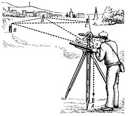
The first situation: the boundaries of the land plot were established in the process of land surveying, but one of the parties believes that in fact the neighbor has seized part of his territory. In this case, to resolve the conflict, it is necessary to carry out the following actions: carry out the removal of points on the ground. This work can only be performed by a licensed land management company.
The essence lies in the establishment of turning points on the ground by specialists carrying out geodetic surveying, which are recorded in the unified state register and are officially the boundaries of the land plot. It is recommended to secure these turning points by installing special boundary marks. This will allow you to clearly show how the border of the land plots passes. If, nevertheless, the conflict is not settled, the dispute must be resolved in court.
The second situation: the exact boundaries of the land plot have not been established, the land plot has not been surveyed, adjacent land users have different ideas about the place where the boundaries pass. In this case, neighboring land plots are conditionally registered in the cadastral register and their boundaries are determined declaratively or are not registered at all. To resolve the conflict, it is also necessary to carry out the following actions: start the process of land surveying.
The boundaries of the land plot are established on the basis of a geodetic survey of the land plot and existing land documents. In geodetic surveying, an important aspect is also the determination of the location of buildings and their location relative to the boundaries of the land plot. An important document of the land survey is the act of agreeing on the boundaries of the land plot with the owners of adjacent land plots, which confirms the consent of the neighbors with the establishment of just such boundaries.
However, if no agreement is reached on this issue, the conflict is resolved at the next stage - judicial. In this case, the court will consider a set of factors, including the actual land use, the results of geodetic surveys, existing land documents, comparison of the areas of land plots, expert opinions.
Disputes are created when registering the rights to land plots according to a simplified procedure, when the boundaries of the formed land plots are not put on cadastral records.
Disputes about the boundaries of land plots are the most common category of cases in the courts. Given the fairly high prices for each square meter of land near Moscow, each owner of a land plot may be involved in the proceedings. To avoid a land dispute, it is necessary to keep the documents in order. Especially documents confirming the boundaries of the land. It was the land dispute that from ancient times led to quarrels up to military operations. In our time, it is most correct to arm yourself with knowledge.
Every interested person can get acquainted with the legislative documents, but not everyone will be able to apply this knowledge in practice. Therefore, if a land dispute arises over the boundaries of a land plot, it is most correct to contact a professional.
Documents required to provide legal assistance in disputes about the boundaries of land plots:
- documents of title to the site;
- primary evidence of violation of rights by adjacent land users (formed by a lawyer).

Violation of the boundaries of a land plot by adjacent land users is one of the most common cases considered by the courts of the Moscow region in the framework of land legal relations. Each owner of a land plot may be involved in legal proceedings if adjacent land users violated the boundaries of the land plot.
To give the violators a decent procedural response, it is necessary to keep the documents in order. Especially documents confirming the boundaries of the land plot. It was the land dispute that from ancient times led to quarrels up to military operations. In our time, it is most correct to arm yourself with knowledge.
Steegle.com - Google Sites Tweet Button
Violation of the boundaries of the land plot is neutralized in court. By virtue of the Land Code of the Russian Federation and the Civil Procedure Code of the Russian Federation, a land dispute is subject to consideration in court in the course of action. Among the most common subjects of a claim are: a claim to establish the boundaries of a land plot in accordance with the cadastral plan or in fact; a claim to determine the boundaries of a land plot in accordance with the cadastral plan or in fact; a claim for the recognition of ownership of a land plot or part of it in accordance with a share in a house or in fact; a claim for overcoming obstacles in the use of a land plot; a claim for the reclamation of a land plot or part of it from someone else's illegal possession.
Everyone can familiarize themselves with legislative documents, but not everyone is ready to apply this knowledge in practice. Therefore, if a land dispute arises over the boundaries of a land plot, it is most correct to contact a professional
How to define the boundaries of a land plot? The answer to this question is quite simple if there is no dispute with adjacent land users. The location of the boundaries of the land plot is determined by determining the coordinates of the characteristic points of such boundaries, that is, points of change in the description of the boundaries of the land plot and dividing them into parts.
The location of individual parts of the boundaries of a land plot can also be established in the manner determined by the regulatory body in the field of cadastral relations, by indicating natural objects and (or) objects of artificial origin, including linear objects, if information about such objects is contained in the state the real estate cadastre and the location of the specified individual parts of the boundaries of the land plot coincides with the location of the external boundaries of such objects.
The procedure for establishing characteristic points of the boundaries of a land plot, the procedure for determining their coordinates, as well as requirements for the accuracy of determining such coordinates are established by the regulatory body in the field of cadastral relations. The area of a land plot, determined taking into account the requirements established in accordance with this Federal Law, is the area of a geometric figure formed by the projection of the boundaries of the land plot onto a horizontal plane.
When clarifying the boundaries of a land plot, their location is determined based on the information contained in the title document for the land plot, or, in the absence of such a document, from the information contained in the documents that determined the location of the boundaries of the land plot during its formation. In the event that the documents specified in this part are absent, the boundaries of the land plot are the boundaries that have existed on the ground for fifteen or more years and are fixed using natural objects or objects of artificial origin, which make it possible to determine the location of the boundaries of the land plot.
Formed land plots must meet the requirements civil law, land legislation, forestry legislation, water legislation, urban planning legislation and other requirements for land plots established in accordance with the legislation of the Russian Federation. If in accordance with federal law the formation of land plots should be carried out taking into account the land survey project or other document provided for by federal law, the location of the boundaries of these land plots is determined taking into account such a document.
Determining the boundaries of a land plot is the determination of turning points of a land plot on the ground. Determination of the boundaries of a land plot is necessary if there is no land management business and cadastral information on the land plot. Determination of the boundaries of a land plot is carried out by determining cadastral data based on the location of the land plot in kind. This is the essence of the conflict - you believe that the actual boundaries of your land plot are legal, and the cadastral boundaries of adjacent land users violate the established procedure for use. Hence - the need to go to court.
A claim to determine the boundaries of a land plot is filed with a court in writing at the location of the land plot. In a claim for determining the boundaries of a land plot, the following must be indicated: the name of the court to which the application is submitted; name of the plaintiff, his place of residence; name of the defendant, his place of residence; what is the violation of the rights of the plaintiff and his claims; the circumstances on which the plaintiff bases his claims and evidence; the price of the claim, if it is subject to assessment, as well as the calculation of the recovered sums of money; information on compliance with the pre-trial procedure for contacting the defendant; list of documents attached to the application.
A claim to determine the boundaries of a land plot is signed by the plaintiff or his representative if he has the authority to sign the application and submit it to the court. Attached to the claim for determining the boundaries of the land plot are: copies of it in accordance with the number of defendants and third parties; a document confirming the payment of the state fee; power of attorney or other document certifying the powers of the plaintiff's representative; documents on which the plaintiff bases his claims, copies of these documents for the defendants and third parties; evidence confirming the fulfillment of the mandatory pre-trial dispute settlement procedure; the calculation of the recovered or disputed amount of money, signed by the plaintiff, his representative.
Establishing the boundaries of a land plot is, first of all, defining turning points (plot corners) on the ground. Turning points are fixed on the ground with boundary marks. Establishing the boundaries of a land plot is also otherwise referred to as taking out in nature or establishing in nature the boundaries of a particular land plot. This view cadastral (land management) work is necessary if boundary marks or other identification marks are lost.
Very often on the land plots put on the cadastral register, after the expiration of time (or for other reasons), boundary marks are not saved, fences are overwhelmed, etc. In these cases, as well as in disputable situations between land users of adjacent land plots (including by a court decision), the removal of the boundaries of the land plot in nature is required.
Determination of the boundaries of a land plot is carried out on the basis of cadastral information. Cadastral information is obtained from the territorial department of Russian real estate. Surveyors (cadastral engineers) are primarily interested in extracts in the form of KB.5 (where the directional angles of the turning points of the land plot are determined) and extracts KB.6 (directly the coordinates of the angles of the turning points).
By the decree of the government of the Russian Federation of August 20, 2009 No. 688, the "Rules for establishing the boundaries of land management objects on the ground" were approved. On the basis of paragraph 11 of the rules, documents and materials obtained during the performance of work to establish the boundaries of the land management object on the ground are included in the land management business.
The establishment of the boundaries of a land plot must be documented in the form of a land management case. Obligatory in this case are: registration of an act of delivery of boundary marks to the customer for preservation and an act of agreeing the boundaries of the land plot with adjacent land users. This is a separate form and if at least one adjacent land user refuses to sign the act, you will have to go to court with a corresponding claim.
ATTENTION! Check the actions of those who carry out land surveying, especially intermediaries. The fact is that there are cases when signatures in the border agreement act are simply forged. You register a plot, erect a fence (barn, garage, house), and then the adjacent land user, whose signature in the act was not affixed, cancels the survey results and seeks to demolish the fence you erected (barn, garage, house).
You can find out in more detail how to dispute the boundaries of land surveying in your particular case, completely free of charge from our lawyers using the direct links located on this page.
